Nitinbhai Highrise Towers — Case Study
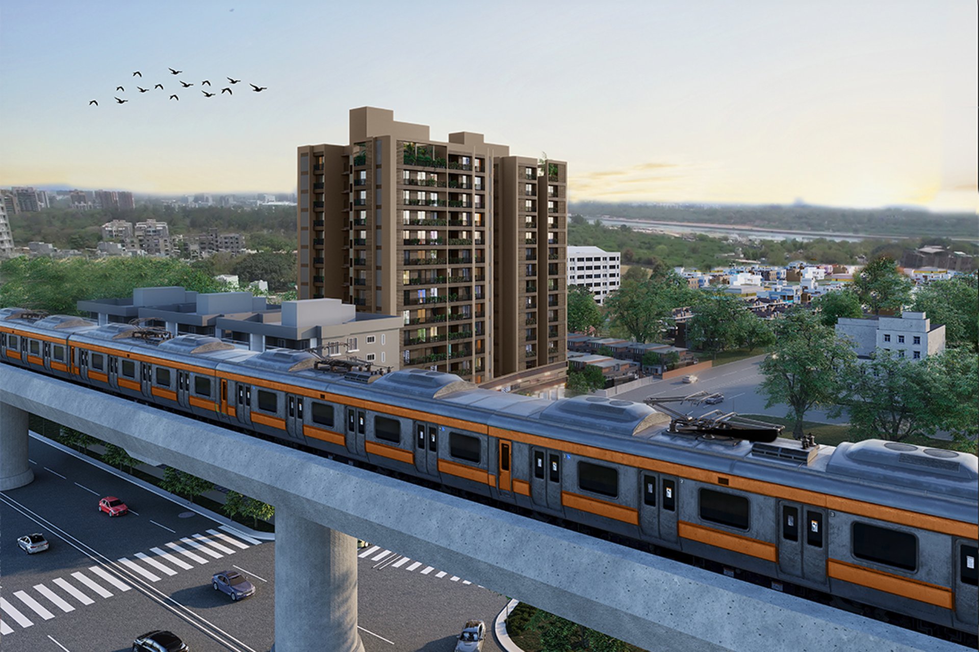
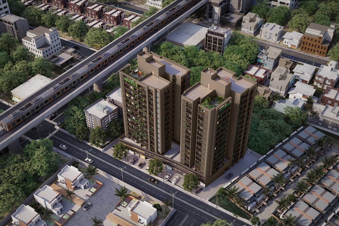
Bird's-eye aerial view of twin 12+ story Indian residential towers in a dense urban context with an elevated metro rail line passing nearby, rooftop greenery, parking podium, and surrounding low-rise neighborhood.
Client
Confidential
Industry
Multi-family Residential Development
Objective
Contemporary High Rise Visualization
Deliverables
Photoreal multi family exterior renders, multiple viewpoints, marketing-ready output
Overview
Nitinbhai Highrise Towers is a twin-tower residential proposal in Ahmedabad: two 12+ storey blocks rising over a parking podium, rooftop greenery on top, and an elevated metro rail line cutting past the site. The surrounding fabric is dense and low-rise. The visualization brief asked for a single hero aerial that resolved all of this in one frame.
The aerial is the hardest viewpoint to do well in a context like this. From the ground, towers can be cropped, hero-lit, and disconnected from their neighbours. From the air, the buildings have to coexist with everything around them. Any misjudged scale, any wrong shadow length, any cartoon tree breaks the image.
This case study walks through what the project category actually demands, where most aerial renders of Indian high-rise schemes fail, and the production decisions that pushed this image past a competent base render into something usable for planning submissions, pre-sales collateral, and hoarding graphics simultaneously.
Where do most multi family exterior aerials fail?
Most aerials of dense Indian sites fail in three predictable ways. They isolate the towers, ignore the metro infrastructure, or paint the surrounding neighbourhood as anonymous beige boxes. The result reads as a sales pitch, not a place.
The brief here pushed the other direction. The metro line was not hidden, the neighbourhood was not flattened, and the podium was treated as a real element rather than a base to mask. That changes how the image is built from the first block-out onwards.
- Surrounding context modelled, not matte-painted
- Metro alignment placed to scale, not implied
- Podium parking treated as a designed surface
- Rooftop landscape resolved as an inhabited layer
- Tree species reading as Ahmedabad, not stock library
What made this hard
The technical challenge was the camera. A bird’s-eye view at this height flattens vertical articulation. Balcony rhythm, fenestration depth, parapet detail all collapse if the lens choice and altitude are wrong. Too high and the towers become diagrams. Too low and the metro context falls out of frame.
The second challenge was lighting. Ahmedabad sun is hard. A midday sun gives strong shadows on tower facades but dead shadows on the podium and rooftop. A low-angle sun rescues the podium but creates extreme shadow tails across the neighbourhood. Neither extreme works for a single hero.
The third challenge was material truth at altitude. From a bird’s-eye, PBR materials that look correct at eye level often read as plastic. Roof tiles, metro track ballast, podium paving, tower glazing, all need their reflectance and roughness re-tuned for the viewing distance.
An aerial render lives or dies on whether the surrounding city looks like it was there before the towers arrived.
How we approached it
The production was structured in four discrete phases. Each phase had a single output that had to be approved before the next started. This sequencing matters because rework on an aerial is expensive: re-lighting a frame this dense can cost a full day of render time.
1. View planning and altitude lock
We tested six camera positions before locking one. The chosen view sits high enough to read both towers in full elevation but low enough to keep the metro line as a reading element rather than a distant ribbon. Lens choice was a moderate wide, not a fisheye, to keep tower verticals honest.
The altitude was fixed early so that all subsequent modelling could be detailed appropriately. Anything outside the camera frustum got base geometry. Anything inside got production-grade detail. That single decision saved several days of unnecessary modelling.
2. Context build and metro integration
The surrounding neighbourhood was modelled as real volumes with real roofs, water tanks, AC units, and laundry. No placeholder boxes. The elevated metro line was built to actual structural proportions: pier spacing, viaduct depth, track gauge, overhead catenary. At aerial scale these read instantly to anyone who knows the city.
Rooftop greenery on the towers was treated as a designed landscape, not a green carpet. Planters, paving, pergolas, and circulation were resolved enough to survive the view distance.
3. Lighting and atmosphere
We used a single HDRI lighting dome calibrated to mid-morning Ahmedabad, blended with a directional sun for shadow control. Mid-morning gave us long enough shadows to articulate facade depth, without burning the podium or losing the neighbourhood to shadow tails.
Atmospheric haze was added in-camera, not as a post effect, so that distant low-rise blocks lost contrast naturally. Ambient occlusion was kept restrained. Heavy AO at this scale produces a sooty, video-game look that erodes the photoreal read.
4. Materials, render passes, and finishing
Glazing was tuned with ray-traced reflections at reduced sample counts in the far field, and full samples on the towers themselves. Concrete, render finishes, and metal balustrades were each given their own roughness map keyed to the altitude. Foliage was rendered with proper translucency, not flat-shaded billboards.
The frame was delivered as a layered composite with separate passes for diffuse, reflection, shadow, AO, depth, and foliage. That made client revisions surgical: a sky swap or a foliage warm-up did not require a full re-render.
Deliverables
| Type | Quantity | Notes |
|---|---|---|
| Hero aerial still | 1 | Bird’s-eye, twin towers in context |
| Lighting variants | Multiple | Mid-morning primary, alternates on request |
| Layered render passes | 6+ | Diffuse, reflection, shadow, AO, depth, foliage |
| Print-resolution master | 1 | Sized for hoarding and brochure use |
| Web-resolution exports | Multiple | Sized for site, social, and presentation |
The layered master is the asset that quietly does the most work. It lets the development team’s marketing function pull crops, recolour skies, and produce hoarding graphics without coming back to us for every variant.
Results
The image worked across the three audiences it had to serve. The architect got a frame that read the massing and the context honestly enough for design review conversations. The development team got a hero asset for pre-sales that did not need to oversell. The marketing function got a print-grade master for hoarding and brochure work.
- Single hero aerial covering planning, sales, and marketing
- Surrounding context legible enough to anchor site reviews
- Metro infrastructure read as a feature, not a liability
- Layered passes enabled in-house variant production
- No re-render cycles required after the first approved frame
The metro line is worth a separate note. Many developers ask for the metro to be softened or removed. Treating it as a feature rather than a problem changed how the scheme could be marketed: proximity to transit is a value, not a defect to airbrush.
Key takeaways
-
Lock the camera before you model. Aerial view planning decides where production effort is spent and where it is wasted; modelling everything to the same level is how budgets evaporate.
-
Context is the photoreal multiplier. A tower rendered in isolation always looks like a render; the same tower placed in an honestly modelled neighbourhood starts to look like a building.
-
Deliver layered, not flattened. Passing the development team a layered master with separate render passes turns one image into a working kit, and removes the bottleneck of small variant requests.
Working on a project that needs compelling visuals? Tell us about your project or explore our full portfolio.
Project Gallery