Suburban Retail Pad
Modern Site Plan Visualization
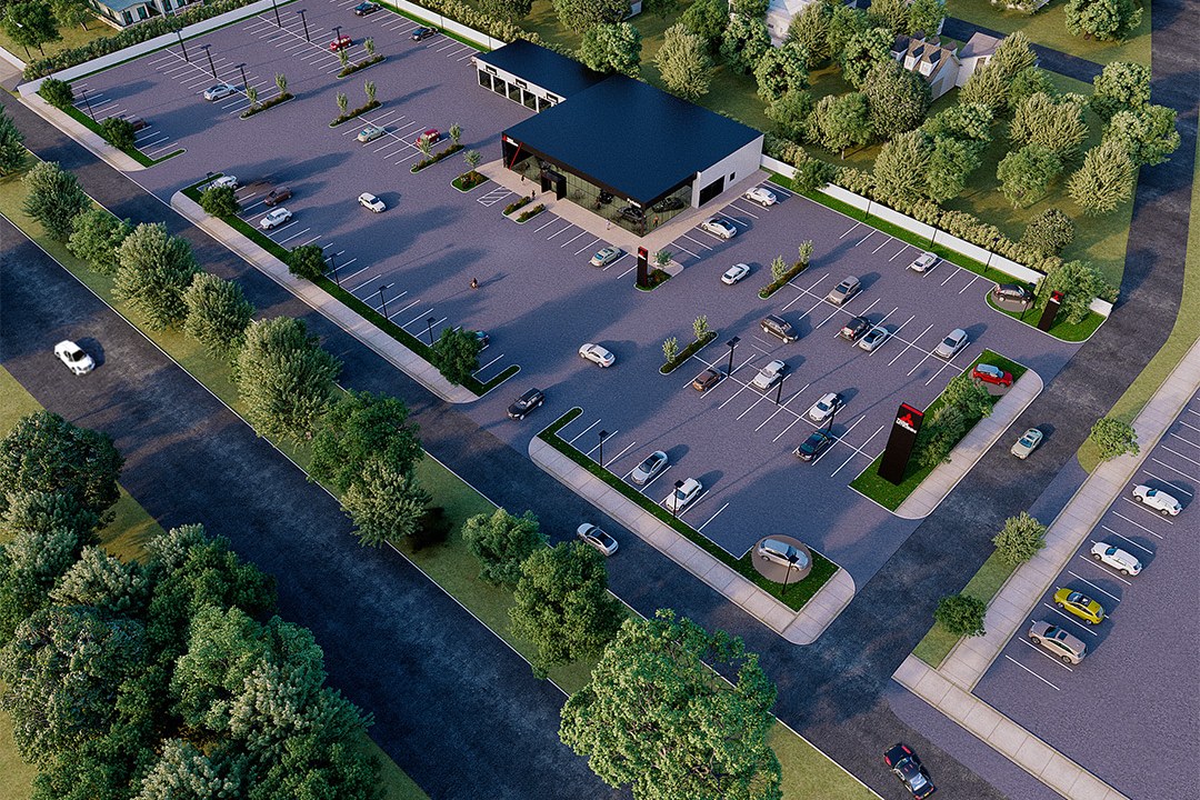
Dusk aerial render of a small freestanding commercial/retail building with a dark flat roof centered in a large paved parking lot with landscaped islands, situated at a suburban intersection surrounded by dense trees and neighboring residential areas.
For our project titled “Aerial Masterplan - Suburban Retail Pad,” our client, a prominent real estate developer, sought a comprehensive visualization to showcase a new retail development in a suburban area. The goal was to create an engaging aerial perspective that would not only highlight the layout and design of the retail pad but also demonstrate its potential impact on the surrounding community. This visualization was crucial for securing planning approvals and attracting potential investors.
Our approach involved a meticulous blend of artistic vision and technical precision. We began by analyzing the site’s context, ensuring that our rendering captured the essence of the suburban environment while emphasizing the retail pad’s unique features. By incorporating elements such as surrounding green spaces and pedestrian pathways, we aimed to create a vibrant and inviting atmosphere. This attention to detail set our rendering apart, allowing stakeholders to envision the project’s integration into the community.
In terms of technical execution, we utilized advanced software such as Autodesk 3ds Max and V-Ray to achieve photorealistic results. We carefully crafted the lighting to reflect a warm, inviting afternoon glow, enhancing the overall appeal of the retail space. Our choice of materials was equally important; we selected textures that conveyed modernity and sustainability, aligning with current architectural trends. The combination of these elements resulted in a striking visual that effectively communicated the project’s vision.
The final rendering proved to be a game-changer for our client. It not only facilitated a smooth planning approval process but also served as a powerful marketing tool during investor pitches. The aerial masterplan successfully captured the imagination of stakeholders, leading to increased interest and confidence in the project’s potential. We take pride in knowing that our work contributed significantly to the project’s success and the client’s overall objectives.
Project Overview
Not every project needs a dozen views. Suburban Retail Pad called for one carefully considered image — the kind that stops a client mid-scroll and gets a meeting scheduled.
Dusk aerial render of a small freestanding commercial/retail building with a dark flat roof centered in a large paved parking lot with landscaped islands, situated at a suburban intersection surrounded by dense trees and neighboring residential areas.
The Result
The final output landed within 1-2 weeks. Clean, high-resolution, ready for print and screen. It’s been the visual backbone of this project’s public-facing materials.
Working on something similar? Let’s talk about your project — or browse more of our work.


